


The Pilots Atlas Eastern Hemisphere (Europe, Middle East and S.E. and Asia)
 JNC scale, topographical charts are used showing over 4,500 airports Waypoints, VOR/DME, NDB´s and special use airspace are included, plus weather frequencies, points of interest, landmarks, airport-directory with ICAO-codes, railways, rivers, major highways, just to name a few. Airports are colour coded by runway length and surface. International/ regional Aerodromes are coded by symbol shape. Pilots now have the ability to point out objects on the ground or know immediately where they are in relation to surrounding airports or points of interest: an all-in-one source of information for pre-flight or during flight.
Pilots Atlas Eastern Hemisphere - Example pages
 |
 |
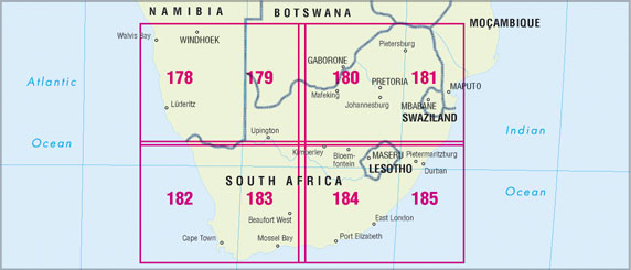 |
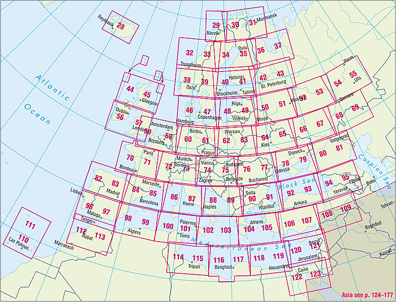
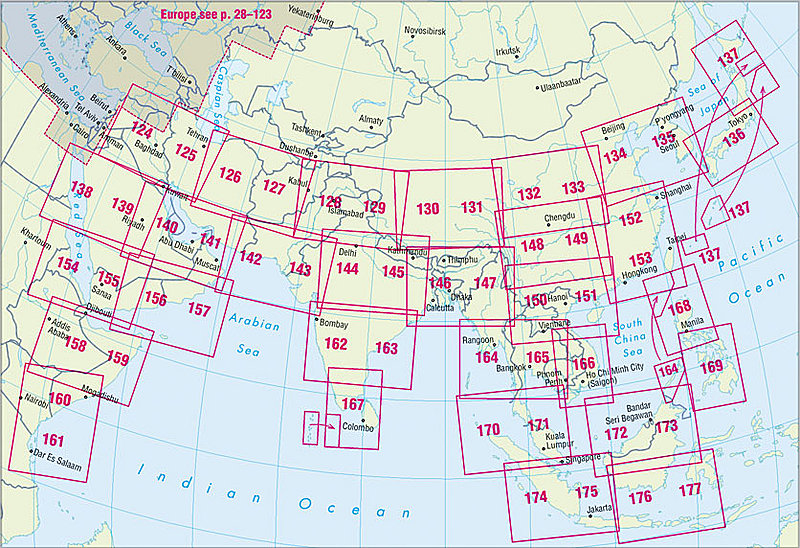
| Keymap Europe, 92 pages cartography Scale 1:2.000.000 | Keymap South East Asia, 40 pages cartography Scale 1:4.000.000 | Keymap South-Africa, 8 pages cartography, Scale 1:2.750.000 |
 |
 |
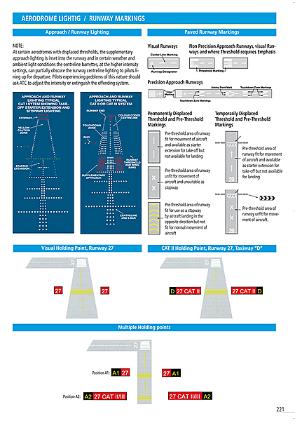 |
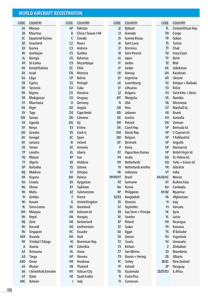
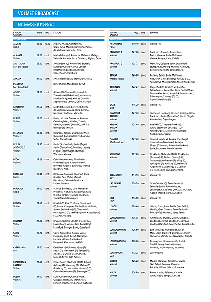
| Captain's Corner, aircraft registration | Captain's Corner, volmet broadcasts | Captain's Corner, aerodrome lightig / runway markings |
 |
 |
 |
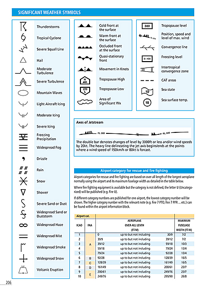
| Captain's Corner, weather symbols | Time zones and web suffixes | Satellite Photo Europe, Climate / Winds |
 |
 |
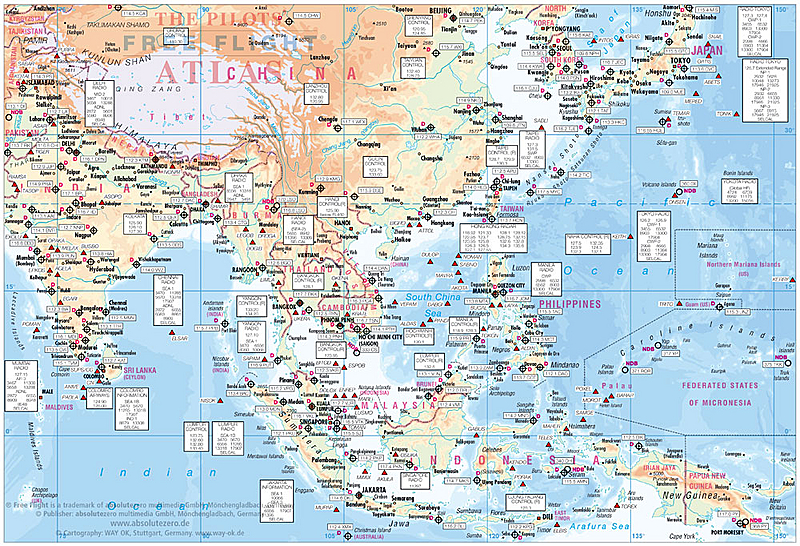 |
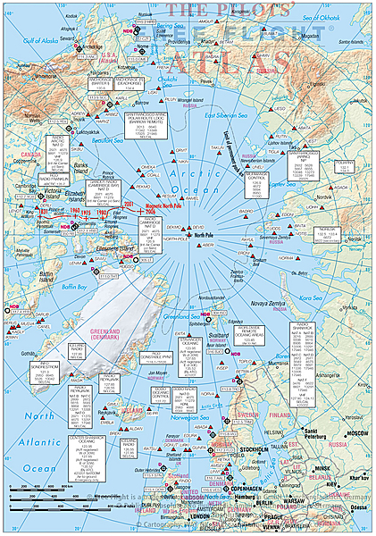
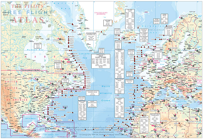
| North Pole overview | Northatlantic overview | Asia overview |
 |
 |
|
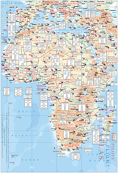
| Africa overview | Pacific overview |
Datas
| Size: | app. DIN A 4 (197 x 284 mm, 77 x 112 inch), 224 pages, 4-color |
| Paper Quality: | Cover: 250 g/qm, wood-free, Glossy-Paper |
| Contents: 65 g/qm, wood-free, Matt | |
| Cover: | Clear foil laminate, Simi-Gloss |
| ISBN/EAN-Code: | ISBN: 3-00-003648-2 and EAN: 9 783000 03648 4 |
| Weight: | app. 480 g |
| Suggested retail price: | 29,99 EUR incl. 7% german VAT |
| Publisher/Copyright: | absolutezero multimedia GmbH, 41189 Mönchengladbach, Germany |
| Overview-maps: | 27 pages |
| Europe-coverage: | 96 pages, scale: 1: 2,000,000 |
| South-Africa-coverage: | 8 pages, scale: 1: 2,750,000 |
| Mid-East & Asia: | 54 pages, scale: 1: 4,000,000 |
| Captains Corner: | 39 pages |
| Beschreibung: | Basiskartographie ist ein Straßenatlas. Basisinformationen wie: Berge, Seen, Flüsse, Bahnlinien, Ländergrenzen, Städte, Dörfer, Autobahnen, Landstraßen, Naturparks und Sehenswürdigkeiten sind natürlich in den Karten enthalten. Hinzu wurden aeronautische Informationen eingearbeitet: über 4.500 ICAO-Codes mit farbiger Unterlegung für die Landebahnlänge, VOR/DME`s mit Frequenzen, NDB´s, Waypoints mit Code und VOLMET-Frequenzen. |
| Übersichtskarten: | 4 Seiten Europa & Asien politisch, 2 Seiten Klima + Winde, |
| 2 Seiten Sternenkarte + Nordpol, 2 Seite Zeitzonen + web-Abkürz., | |
| 2 Seiten Nord-Atlantik-Übersicht, 2 Seiten Afrika- Übersicht, | |
| 4 Seiten Asien + Mittlerer Osten- Übersicht und 2 Seiten | |
| Pazifik- Übersicht, 2 Seiten Australien- Übersicht. | |
| 1 double page North Atlantic routes | |
| 1 double page African continent | |
| 2 double pages Asia routes to Japan | |
| 1 double pages Pacific routs | |
| 1 double pages Australia routs | |
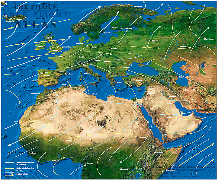
| 1 double page North pole and starchart and 4 pages Satellite picture Europa & Asia with mainwinds avrage, | |
| 2 pages Europe & Asia political map | |
| 1 page star chart | |
| 1 page polar chart | |
| 2 pages timezones with web-suffixes | |
| Captains Corner: | 39 pages of aeronautical information updated with the latest JAA information. To the Airport Directory in the Captains Corner, we have added the coordinates (Lat / Long) for every airport. World Aircraft Registration, Volmet-Broadcasts, Weather Symbols, Metar, Climb Gradients, Conversion Tables, Crosswind Component, Holding, Aerodrome Operating Minima, De-icing Table, Aerodrome Signs + Signals and Abbreviations and….. |
Subcategories
Atlas Europe & Eastern Hemisphere - samples -
Atlas Europe & Eastern Hemisphere - samples